What You Need To Know Before Starting A Project Near Creeks And Waterways
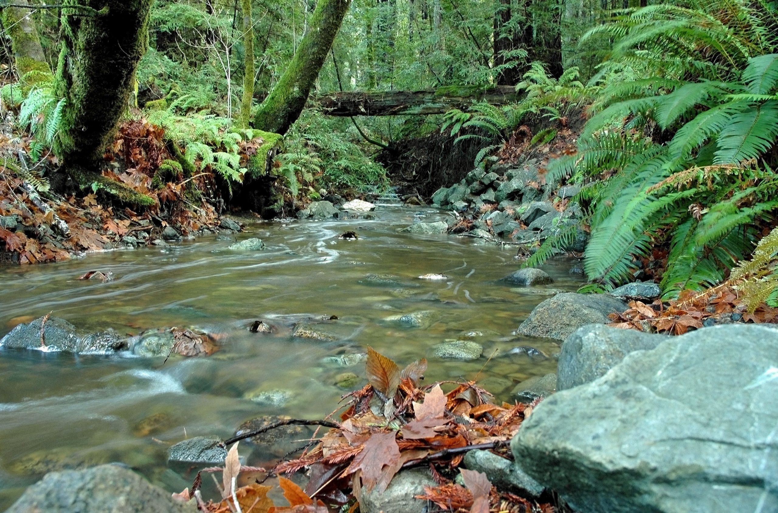
Marin County has over 3000 miles of natural creeks. Some of the creeks remain relatively natural, while others have undergone many changes such as dams and channel alteration resulting from development within the watershed. These alterations can often cause damage such as head cuts, channel incising, bank failures, and flooding.
When damage occurs, restoration and creekbank repairs are often needed. This work must be done properly or further damage may be done either at the existing site, or often up or downstream from the repair. That’s why work in all perennial, intermittent, and ephemeral (only flow during storm events) waterways requires permits.
Learn more about creek work and how you can protect Marin’s creeks and watersheds below.
Most creek repair work requires permitting through the following agencies:
- Your local municipality
- The California Department of Fish and Wildlife
- U.S. Army Corps of Engineers
- The Regional Water Quality Control Board
- and occasionally other agencies such as the Bay Conservation and Development Commission (BCDC)
See below for helpful guidance and resources. Also, check out the San Francisco Regional Water Board’s stream maintenance and enhancement projects best management practices and permit requirements and Marin County Guide to Creek and Wetland Permits for additional information.
Note: Permitting agencies favor projects with design elements that will protect and enhance the natural environment. See our Creek Care Guide and Repairing Creekbank Erosion for more information.
Your bank stabilization project should be designed to help the stream attain a stable creek structure and incorporate features that create and sustain instream habitat. Your project should never impair, and where possible, should enhance the natural creek functions. For more information in preparing for your project, see the Local Creek Permit Checklist below.
Checklist
- Describe how the project will help the stream attain an equilibrium condition so that the channel will erode and transport sediment and create and sustain instream habitat without creating conditions leading to excessive erosion and/or excessive deposition. In the process of addressing this issue of equilibrium, explain what factors are influencing the channel you are working with, such as:
- Is the bed materials composed of fine sediments, gravel, cobble, or bedrock?
- Is the stream influenced by landscape features such as alluvial fans or tides?
- What are the channel slopes and valley slopes, and what is the condition of the streamside riparian vegetation?
- Stream channel classification systems can be used to aid your descriptions of the conditions and channel types.
- Describe the dimensions of the stream’s active channel or bankfull channel that you plan to protect or restore to achieve a balanced sediment transport and storage.
- Describe how these dimensions are derived. Provide information on the drainage area of the watershed being drained to your project site.
- Describe how the project protects and/or restores the floodplain.
- Describe how the project protects and/or restores the native streamside vegetation.
- Describe how the project protects or restores the stream channel slope by avoiding destabilizing grade control structures and/or by addressing an equilibrium channel length. Provide information on the valley slope and the proposed channel slope and sinuosity of the stream.
- For projects that entail the restoration of stream banks, provide information on the shear stresses expected to act on the banks and what soil bioengineering systems are proposed to address the stabilization needs.
- Are salmonids present in the stream where your project is located or could salmonids reach this area if migration barriers were to be removed? If so describe how the proposed project will avoid or remove migration barriers and protect or enhance spawning or rearing habitat.
For many of the smaller scale projects it may only take two pages of information to adequately describe this information. Large scale projects will require more analysis to cover these points. Owners of small parcels, as well as large project proponents may need to seek assistance from trained professionals to help address these informational needs.
For information about the MPC, or to be placed on the agenda, call MCSTOPPP staff at (415) 473-3748.
While these permits can all be applied for concurrently along with local permits, the permitting can be a lengthy process and may sometimes take up to a year depending on the complexity of your project, especially if CEQA Review and or design changes are required. There are also restrictive work windows prohibiting working during the rainy season, and additional requirements if endangered species are potentially present.
Be sure you are providing a complete application by using the correct format required by each agency. Please note that the Joint Aquatic Resources Permit Application (JARPA) has become outdated and is being phased out as a method to apply for State and Federal resource agency permits.
Information for the Army Corps of Engineers Nationwide Permit (NWP), including the Pre-construction Notification (PCN), drawing and map standards, and NWP general conditions can be found on their Nationwide Permit Program page.
Information for the Regional Water Quality Control Board’s 401 and WDR Permits can be found on their Water Quality Certification page.
The CA Department of Fish and Wildlife has transitioned to the online Environmental Permit Information Management System (EPIMS), for all Lake or Streambed Alteration (LSA) notifications. EPIMS is now CDFW’s only method for receiving standard LSA notifications. For more information please visit their EPIMS website.
Contact information for permitting agencies is provided below.
P.O. Box 47, Yountville, CA 94599
(707) 944-5520
Fish and Game Code section 1602 requires any person, state or local governmental agency, or public utility to notify CDFW before beginning any activity that will substantially modify a river, stream, or lake. To obtain permission from CDFW to proceed with your project you need to submit a Lake or Streambed Alteration Notification Form using their online EPIMS system (see Applying for Permits above). For permit fees please see the CDFW website.
San Francisco District U.S. Army Corps of Engineers
1455 Market Street, San Francisco, CA 94103-1398
(415) 503-6795
Streambank repair work often comes under Nationwide Permit 13: Bank Stabilization, and there will be no charge for the permit. If your project does not fall under Nationwide Permit 13 requirements, and depending on the details of the repair, the permit fee may be up to $100.
San Francisco Bay Area Regional Water Quality Control Board
1515 Clay Street, Suite 1400, Oakland, CA 94612
(510) 622-2300
The RWQCB issues 401 Water Quality Certifications for all Army Corps of Engineers permits. For permit fees please see the RWQCB permit fee schedule on the website. This agency may require some additional information that is not requested by other agencies. Check their website (see Applying for Permits above) for the most recent requirements.
National Oceanic and Atmospheric Administration Fisheries (NOAA)
– Formerly Known as National Marine Fisheries Service (NMFS)
Environmental Protection Agency (EPA)
State Water Resources Control Board
Sacramento Army Corps of Engineers
Disclaimer: Every attempt has been made to assure that the information contained above is accurate. The Marin Countywide Stormwater Pollution Prevention Program assumes no responsibility and disclaims any liability for any injury or damage resulting from the use or effect of any product or information specified above.
The ultimate success of your project starts with planning and design. Knowing what your options are for a restoration versus a repair may also simplify the permitting process.
- Repairing Creekbank Erosion – A downloadable guide on who to call for permits, how to outline the project before you begin, the steps to take, and how to follow up on your repair.
- Groundwork: A Handbook for Small-Scale Erosion Control in Coastal California – 2nd Edition from the Marin Resource Conservation District and MCSTOPPP.
- Stability Thresholds for Stream Restoration Materials
- Stream Maintenance and Enhancement Projects Best Management Practices and Permit Requirements – San Francisco Regional Water Board fact sheet from 2015.
- For information on Proposed Bank Stabilization Guidelines for Novato Creek, read the report produced by the Marin County Department of Public Works: Proposed Bank Stabilization Guidelines for Novato Creek
- Surface Flow – Often the easiest to address. Water flowing over the top of the ground usually causes steep, vertical bank erosion. Common sources include culverts, driveways, ditches or drainage from roofs.
- Ground Water – Water flowing a few inches to a few feet below the ground frequently surfaces on a streambank before reaching the creek channel. Planting these areas with native plants is a good method for controlling erosion caused by groundwater. Check to make sure you are not indirectly contributing excess subsurface flow through yard or garden irrigation.
- Stream Dynamics – Natural changes – such as big storm events or human activities – can cause the stream channel to adjust. Removing vegetation along a creek can reduce streambank stability. This can lead to streambank failure, particularly during large storm events.
Modifications to creek flow may increase erosion both upstream and downstream – An increase in sediment from erosion in the watershed will cause alternate banks to erode in a classic “S” pattern as growing gravel bars direct stream flow into the opposite bank. A fallen tree or other obstruction can cause site specific erosion.
Not all erosion is bad – Streams need to be able to adjust to events in the watershed by changing their shape. Undercut banks and fallen trees provide important habitat for salmonid fish (salmon and steelhead) and other stream dwellers. Answering the following questions may help you to determine whether to intervene, or let nature take its course.
- Is the erosion threatening a structure, road, utility pole, or other important property?
- Is the erosion threatening riparian habitat or a significant tree?
- Is the erosion extremely active? Does it erode rapidly during most rainstorms?
- Does the erosion appear to be caused by a person-made change, such as a road, culvert or yard drainage?
- Photograph the site. It is a good idea to include some sort of reference object (such as a shovel, a basketball, a person in the photo, etc.) to help indicate the size of the actively eroding area.
- Make a sketch of the site. Include length, width and height of the eroding area. Show structures and how far away they are. Include vegetation and any biological information you know, (what kind of fish use the creek there, etc.)
- Walk up and down the stream if you can. Indicate on your sketch what is happening near your site. Usually something happening upstream is causing the erosion to occur, such as rock rip rap, a fallen tree, or anything that might redirect the flow of water. Are your neighbors experiencing similar erosion problems as well?
- Observe the water flow. Does water flow year round? Does water only flow when it rains? Does the creek dry up in the summer?
Cooperative Projects – If some of your neighbors have similar stream bank erosion problems, you might want to consider working together. Benefits include sharing the permit and planning costs, and building repairs that complement and even enhance each other. Cooperative projects, done in conjunction with a local agency or group, can also be eligible for private or government grant programs.
- Remember the needs of fish and wildlife – Does your design include native plants that will provide habitat and refuge for wildlife in the creek? Is your setback from the top of the creek bank adequate to allow appropriate riparian vegetation to grow along the creek? The extensive root systems of some native plants can help with stream bank stability. Even rock rip rap, when interplanted with willows or other trees can enhance habitat.
- Be sure not to constrict the channel – By placing your retaining wall or rock work too close to the center of the stream you may be inadvertently reducing the space the water has to fit through the creek and you may be causing yourself more problems down the road, or causing erosion to occur on your neighbor’s properties.
- Biotechnical Restoration – Biotechnical restoration is the term used primarily for using native vegetation to secure an eroding bank. The term biotechnical is synonymous with the term “bioengineering”. Generally speaking this type of work is mostly planting, and usually does not require any permits. If your erosion problem is in an early stage that might be appropriate for some biotechnical restoration, this option will be much less expensive than an engineered design that may require permits. If you have enough time and room as a first step, try a restoration approach using biotechnical techniques initially. If for some reason they fail, and you have documented your efforts, this is a good basis for supporting your need for a hard surface design (rock rip rap, retaining wall, etc.). For more information on biotechnical restoration, see Stream Corridor Restoration: Principles, Processes and Practices, or Ann Riley’s primer on Stream and River Protection for the Regulator and Program Manager.
- Engineered Solutions – Sometimes bank restorations and repairs require an engineered solution. All engineered projects should integrate river science into the design; this method is sometimes referred to as the ‘Geomorphic Approach’. Projects that incorporate geomorphic principles are designed to help the stream attain an equilibrium condition so that the channel will erode and transport sediment, and incorporate features that create and sustain in-stream habitat. Your project should never impair, and where possible, should enhance the natural creek functions. Some examples of bio-engineered or biotechnical designs include restoration of a stable creek channel and floodplain, willow wall structures, installation of brush matting, and vegetated rock rip rap. These and other approaches are addressed in the manuals referenced above.
- Permitting – Most creek bank repair projects require permits from the U.S. Army Corps of Engineers, the Regional Water Quality Control Board, CA Department of Fish and Game, and your local municipality. Go to our Creek Permits panel above for application forms and instructions.
- Preserve Water Quality – Be careful to protect water quality and existing habitat during construction. Proper measures should be taken to avoid muddying water in the creek. Protect existing native plants along the bank if possible, or salvage native plants prior to construction and incorporate them in the re-vegetation stage of the project. Generally, all work should be scheduled for the low flow period, usually between June and October.
- Watering – Projects that involve planting new plants often require watering for the first few summers in order for the plants to take successfully. Many large failures are caused by small problems that could have been avoided if caught early on. Check your repair before the winter rainy season and after each storm. Take photographs after a year or two from the same point where you shot the “before” photo. It’s fun to watch the sites vegetation mature and settle in, and it may also help others design effective repairs.
- Be a Model – Share your successes with MCSTOPPP! We’d like to have a list of sites that have been repaired (especially those incorporating biotechnical designs), that we can use to recommend this approach to other property owners with similar problems. If you have photos or success stories, please email them to us.
Good luck with your restoration projects!
Each municipality and the county have their own setback requirements. The various available creek setback requirements are listed below by municipality. You can also contact your local municipality for the most current updates.
Adequate setback between creeks and/or drainageways and a structure shall be determined based on the following criteria:
- The setback provides for adequate maintenance, emergency vehicle access, adequate debris flow avalanche corridors, flood control and protection from damage due to stream bank undercutting;
- The setback adequately protects and preserves native riparian and wildlife habitat;
- The setback protects major view corridors and provides for recreation opportunities where appropriate;
- The setback permits provision of adequate and attractive natural landscaping.
No new building or substantial reconstruction of an existing building should be located within twenty-five feet (25′) of the top of the bank or bulkhead along both sides of the San Rafael Canal between Highway 101 and the mouth of the canal. Upon adoption of a design plan for the San Rafael Canal, the design plan provisions shall control.
Pedestrian and bicycle access is encouraged along creek and drainageway corridors where feasible. However, they should be designed and located so as not to adversely affect important habitat areas. Creeks and drainageways should also be enhanced where feasible to serve as wildlife habitat as well as drainage facilities.
Any proposed fill in a creek, drainageway or in the San Rafael Canal shall be subject to the requirements of City Code Section 14.13.040(G), Fill. A use permit for fill shall be required consistent with Sections 14.13.050 through 14.13.070. (Ord. 1625 § 1 (part), 1992).
The following list contains links to a variety of publications and resources relating to creek care.
- Stream Maintenance and Enhancement Projects – Best Management Practices and Permit Requirements – San Francisco Regional Water Board fact sheet
- Guidelines for Protecting Aquatic Habitat and Salmon Fisheries for County Road Maintenance – 2004 guidence manual developed by FishNet 4C.
- Local Clean Water Ordinances
- Marin County Bioassessment: Evaluation and Recommendations for Future Monitoring
- Marin Watershed Program – Provides a framework to integrate flood protection, creek and wetland restoration, fish passage, and water quality improvements to protect and enhance Marin’s watersheds. Site includes watershed maps.
- Map of major streams and watersheds in East Marin and West Marin
- Native Plant Nurseries
- The Story of Iron Oxidizing Bacteria – Experiencing an orange substance in the creek? It may be the presence of a natural organism living in the water.